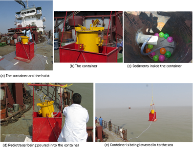
Maintenance of the navigation channel leading to the dock is a prime concern of any port authority for movement of ships with adequate draft. Generally dredging is done to improve the draft in the shipping channel. For example, in Kolkata Port the navigational channel leading to Haldia from the outer estuary requires maintenance dredging throughout the year. Five to six Trailing Hopper Suction dredgers are deployed to maintain the navigable depth over the shallow critical stretches leading to Haldia Dock Complex. These dredgers use the tidal window to dredge over the critical shallow area, fill up their hoppers and then move to the dumping grounds to dispose of dredged materials in a deeper area (open river disposal). In this process, movement of the dredgers between the dredging site and dumping site takes more time than the actual dredging work. Hence the total cost becomes prohibitive. Dumping into a nearby site may reduce the cost, but there is always a possibility of return of the disposed materials to the dredged site during return of tides. This project aims to identify the movement and dispersion pattern of the dredged materials, using Radiotracer Experiments in the Sea, followed by Hydrodynamic Modeling of the sediment dispersion process. The present navigational channel in the Hugli estuary near the disposal site is selected as the area under study. Experiences and expertise of the Kolkata Port Trust (CI) regarding the complex nature of the navigational issues and dredging problems helped in obtaining relevant information of flow phenomenon in the said reach. Industrial scale radio-tracer techniques that are practiced and pioneered by IAD, BARC (PC) have been applied to the reach to identify the dynamics of dispersion of the dredged materials. Appropriate hydrodynamic sediment transport model of the said reach of the estuary are being developed by the PI at IIEST, Shibpur. Observations from the radioactive tracer experiments and the results of the hydrodynamic models are being compared for verification and validation. Integration of results of numerical simulation and radiotracer experiments is expected to provide better understanding of sediment dynamics in similar coastal areas.